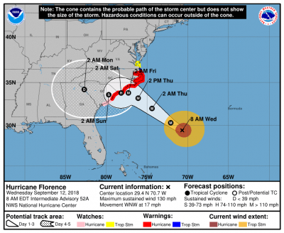
Hurricane Florence - 8 AM Update

Based on the 8 am forecast model from the National Hurricane Center, Hurricane Florence remains an intensive Category 4 hurricane with maximum sustained winds of 130 mph. The storm is expected to make landfall Thursday evening around the SC/NC border, however the latest forecast indicates a westward shift into SC after landfall. Obviously the latest projection is not encouraging.
Our office is located in the northeast region of SC. Our area will be significantly impacted by this hurricane. Today, a hurricane warning was issued and forecasters are calling this is a "life threatening" storm.
So our employees can travel home safely and make last minute storm preparations, we will close early at 4 pm est on Thursday. In addition, will be CLOSED ON FRIDAY for the storm.
We encourage all clients to submit their schedules prior to Thursday to ensure proper funding. If you need special assistance on Friday, let us know before end of day Thursday. We will endeavor to assist you as much as possible.
All decisions on next week's schedule changes, potential delays, and other measures will be made once we properly assess the storm's damage and our power situation. Please refer to our Online Account Portal, social media sites and other normal communication channels for continued updates.
For our customers in the impact area, we are praying for you and your family. Please keep safe.


